Sunday, September 30, 2012

Cahokia Mounds


Above is a picture of the remains of an enormous terraced mound in Illinois, known today as Monk's Mound It apparently received that name because a small community of Trappist monks lived in the area in the early 1800s, causing the American judge and writer Henry Brackenridge (1786 - 1871) to name the massive structure "Monk's Mound." 

While its shape and dimensions have undergone considerable degradation over the centuries, causing its original size to be open to interpretation and debate, this huge earthwork is well over 1,000 feet long by nearly 800 feet wide, and reaches a height of about 100 feet.  

Monk's Mound is the largest of a complex of smaller mounds which surround it at various distances in all directions, some of which have been completely obliterated by the incursions of modern construction (of roads, subdivisions, and a gravel yard).  The complex is known as Cahokia Mounds, and it is located just east of St. Louis, on the western edge of Illinois.  Since the 1960s, the remains of several circles originally composed of vertical wooden posts have been discovered inside the complex.  These are known as Woodhenges and there may have been as many as five within the Cahokia complex.

Although conventional historians are adamant that such mound complexes must have been constructed by Native American tribes, in previous centuries there was much speculation about "mound builder" cultures that may have come from or had contact with other ancient cultures from across the oceans.  This possibility is roundly criticized by conventional historians today.  Typical of the tone and language employed in such criticism is this Wikipedia entry under the heading "mound builder (people)," which declares: "At one time, the term 'mound builder' was applied to the imaginary race believed to have constructed these earthworks" (entry accessed September 30, 2012).

While it is of course possible that these mound complexes and associated Woodhenges were constructed by Native American peoples, it is regrettable that the possibility of trans-oceanic contact has been so completely suppressed since the late 1800s.  This suppression is particularly regrettable in light of the extensive evidence that goes against the conventional "isolationist" theories (see this previous post for a list of several types of evidence, with links to other posts discussing each). 

The dauntless Martin Doutré, who applies his detailed analysis and extensive base of knowledge to numerous ancient sites around the globe (including many lesser-known sites in places that have not received as much publicity for their ancient monuments, such as New Zealand, China, Korea, and Arizona and other locations in the US), has published an outstanding examination of the Cahokia Mounds complex and found many angles and measurements which strongly suggest a connection to ancient sites across the oceans, including to well-known henges in England.  

That study, available on Mr. Doutré's website,  is eleven webpages long and filled with detail and numerous photos.  Here are the links to each page: page 1, page 2, page 3, page 4, page 5, page 6, page 7, page 8, page 9, page 10, page 11.

Mr. Doutré believes that the Cahokia Mounds complex was a giant outdoor training ground for trans-oceanic navigation -- just as the Avebury Henge complex in England is as well, in his analysis (a complex which, perhaps significantly, also features massive earthen mounds such as Marlborough Mound and Silbury Hill).  Among the compelling evidence Mr. Doutré offers for concluding that the Cahokia Mounds complex was the product of people familiar with the pattern employed in England and other ancient sites around the globe are:

  •  The incorporation of Woodhenges, which he argues were a kind of "elementary school" where the important numbers and navigational skills could be taught and practiced in a smaller setting before moving on to the larger-scale training grounds -- just as Mr. Doutré believes the Woodhenge near Durrington Walls Henge in southern England was used for the same purpose.
  • The incorporation of numerous significant angles and numbers relating to precession and to navigation on our spherical earth.  For example, the mound today known as Mound 60 is located 2,160 feet from the central hub on the summit of Monk's Mound (see discussion on page 7 of Mr. Doutré's analysis)  -- and we know that 216 is an important precessional number and one that was incorporated in sites around the world (including a site in Iceland -- see this recent post on the discoveries of Einar Palsson and Petur Halldorsson).
  • Connections to angles and distances used at other ancient monuments, such as Avebury.  For example, Mr. Doutré finds that the azimuth angle and distance to Mound 10 from the central hub on Monk's Mound are 354.375 degrees at a distance of 3,543.75 feet, which corresponds to "the distance and angle relationship existing between Avebury Henge's centre obelisk position and the doorway into West Kennet longbarrow (Southern England)" which has a distance of 7,087.5 feet (which is twice 3,543.75 feet) at the identical azimuth of 354.375 degrees (see discussion on page 3 of Mr. Doutré's analysis).
There are hundreds of other data points cited in Mr. Doutré's analysis -- the above are called out as a representative sampling to demonstrate the strong case that can be made for ancient trans-oceanic influence upon the design and layout of the Cahokia complex.

Arguing that there may have been contact across the oceans thousands of years ago should not be seen as an argument that some races or cultures are "better" or more capable than others, although some critics would seek to silence all speculation of ancient global contact as "racist."  Looking at all the possible explanations (including the theory that the Cahokia Mounds and other sites are the product of more recent Native American construction efforts) should be permitted without name-calling or attempts to impugn the motives of those who seek to examine the evidence and analyze it to the best of their abilities.

Monk's Mound and the Cahokia Mounds complex is an incredible historic treasure that should be more widely known and widely studied.  We are all fortunate that thinkers like Mr. Doutré's have turned their talents towards its analysis, and should carefully consider their conclusions and see whether there are other theories which explain the evidence better or not. 

There appears to be substantial evidence at Cahokia Mounds to support some conclusions about the ancient history of mankind that are very different from what those in control of education for the past century want us to believe.
Thursday, September 27, 2012

The incredibly important analysis of Petur Halldorsson and "The Measure of the Cosmos"


The above interview on Red Ice Radio with author and researcher Petur Halldorsson has to be one of the most important and exciting discussions I have encountered in a long time.  As with all interviews on Red Ice, the first hour (video above) is free to the general public, and the second hour is for subscribers only -- and well worth subscribing just to hear the second hour (by subscribing, you also get access to all the other interviews, including the extensive Red Ice archive).

Mr. Halldorsson, of Iceland, has -- for the past thirty or so years -- followed up on the work of the late Icelandic scholar Einar Palsson (1925 - 1996), whose work involved locating the terrain and sites of the great Icelandic saga Njalssaga (telling the grim events surrounding the hero Njal and his enemies and his family).  

Dr. Palsson and Mr. Halldorsson discovered that the actual locations of the saga mark out alignments to the rising and setting points of the sun at summer and winter solstice, as well as the crossing point of the two axes between these rising and setting points.  Further, they found that the markers creating these alignments (whether buildings, monuments, or prominent natural features) are located precisely 108,000 feet from the center of this huge circle (over twenty miles in radius, and over 40 miles in diameter).  

Also, from this center point, buildings or monuments or features frame a smaller square or "sacred cube" in a very specific way -- see some of the excellent diagrams from Mr. Halldorsson's book, The Measure of the Cosmos, which are reproduced at the Red Ice site here

What makes this discovery so important is the way it sheds light on many other sites worldwide. Mr. Halldorsson has found the same pattern at significant sites at other places on our globe, including England, France, Jerusalem and Italy.  Here are the links: Iceland, England, France, Italy.  Mr. Halldorsson's website, here, also contains papers describing these and other sites, including this one on the Holy Land.

Passing reference is made during the second hour of the interview to the fact that the numbers involved in these sites (usually diameters of 108,000 feet but sometimes diameters of 216,000 feet) are precessional numbers.  The conversation does not dwell on that fact for very long, but 108 and 216 are two of the most important and prominent precessional numbers, found in legends worldwide (even preserved in China).  Here is a video I made explaining the precessional numbers in greater detail and discussing the importance of 108 and 216.

The work of Dr. Palsson and Mr. Halldorsson goes well beyond the prominent use of the precessional numbers, however, and helps tie together many extremely important threads from mankind's ancient past.  In the interview, for example, some time is spent discussing the concept of the cube and the hexagon (and how a hexagon is a two-dimensional representation of a cube), a very important theme which ties in with the work Ross Hamilton has done regarding the Great Serpent Mound in Ohio (see also the discussion here). 

Interestingly enough, a mighty hexagonal cloud pattern has been found on the planet Saturn, and as Giorgio de Santillana and Hertha von Dechend discuss at length in their essential 1969 text Hamlet's Mill, the ancients (including the Pythagoreans) often associated Saturn with the geometric shape of the cube.  Note that Saturn is the sixth planet from our sun (something that the ancients should not have been able to figure out, according to most conventional versions of history, since most conventional historians assert that the ancients did not know that the earth even went around the sun and thus would not have thought of earth as the third planet from the sun or Saturn as the sixth).

Further, de Santillana and von Dechend cite numerous ancient traditions associating the figure of the cube with a "stopper" that either started a worldwide flood (when it was pulled out) or ended the same flood (when it was put in place) -- and that some other ancient traditions don't refer to a cube but rather to a nail (which, when pulled out, started the flood).  What was the name of the hero of that Icelandic saga again?

During the Red Ice interview, Mr. Halldorsson describes this sacred cube area found within the center of these monumental circles as an area of peace, and goes on to discuss the measurement of the "king's girth" in England, as ordained by King Athelstan -- a very important connection.  The "king's girth" of King Athelstan is discussed in this previous post.  That post argues that the measurements in Athelstan's proclamation may preserve a precise understanding of the size of our spherical earth -- something that other evidence shows was known by ancient civilizations long before conventional history teaches it could have been known.

Mr. Halldorsson certainly indicates that the evidence he has found may support the conclusion that seafarers knew the location of Iceland and visited those shores long before the traditional date of settlement of AD 864.  In fact, in their excellent book How the SunGod Reached America, c. 2500 BC (discussed in this previous post), Dr. Reinoud M. de Jonge and Jay Stuart Wakefield provide revolutionary analysis of the stone arrangements and the spiral patterns and circular patterns of ancient megalithic art which supports the conclusion that many of these patterns function as accurate maps to cross the Atlantic, and indicate the location of the Azores, the Cape Verde Islands, the Canary Islands, Iceland, Greenland, and the coastline of North America and the Caribbean.  On page 5 of that book, for instance, they analyze a drawing from around 2700 BC from south Brittany (in France) which indicates the location of Iceland and Greenland (although not yet the Americas, according to those authors).

Finally, Mr. Halldorsson discusses the origin of the peoples who left these ancient "Measures of the Cosmos" all over Europe, and the possibility that they might have come from ancient Egypt -- pointing out that the name of Iceland (and some locations there) may well derive from the word "Isis" rather than "Ice" as we normally assume.  Since the goddess Isis is one of the stars and central figures of the precession-rich myth of Osiris, and since the Osiris myth contains the precessional number 72 which relates directly to the 108 and 216 of these circles discovered by Dr. Palsson and Mr. Halldorsson, the possibility of such a connection should not be neglected.

In sum, there are numerous intriguing possibilities suggested by the important work of Dr. Palsson and Mr. Halldorsson (far too many to mention here).  It is very likely that many other ancient sites around the world will be found to conform to the pattern they first noticed in Iceland.  The world owes them a debt of gratitude, and researchers and analysts from many different fields and backgrounds should contact Mr. Halldorsson to discuss ways to help him with his ongoing research and ways that his findings connect to their own areas of interest or expertise.

If you have not yet done so, be sure to check out his excellent interview, his website, and his book.

Saturday, September 22, 2012

If you were born in 1940 . . .


Happy birthday!  If you were born in the year 1940, then this year you are "one degree of precession" old!  Some very special people reach that special age this year.

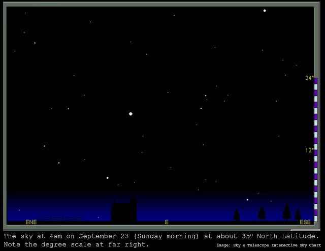
The map above shows the pre-dawn sky, facing east.  We can use this illustration to discuss "one degree of precession."

Right now, the pre-dawn sky above the eastern horizon is pretty spectacular, with Orion followed by Sirius beautifully visible, and above Orion the Hyades and the Pleiades.  Shifting our gaze along the horizon and going towards the north pole from Sirius and Orion, we will find the majestic Lion (Leo) rising up out of the horizon, barely clearing the horizon before the rising sun engulfs the sky in light and the stars retreat from view until sundown.  This year, the brilliant planet Venus is hanging in the sky like a shining jewel just beside the Lion.  

For a wider-view diagram than the one above, a diagram which will show the position of Sirius in Canis Major relative to the Lion, see this post from a couple weeks ago.  For a post discussing the other beautiful stars and constellations that can be easily located starting from Orion, see this previous post (it discusses those stars in the context of winter, when they rise above the eastern horizon after nightfall, but right now they are rising above the horizon before daybreak, and rising a bit earlier each day, and as they continue doing this in the coming months they be in the above locations earlier and earlier in the night, until they are in the eastern sky in the hours after sunset instead of in the hours after midnight).

Below is the same image as the one above (both from the very helpful and free Interactive Sky Chart tool from Sky & Telescope).  I have drawn in the lines for the zodiac constellations Leo and Cancer and marked the bright stars Regulus (in Leo, his forepaw), and Procyon (in Canis Minor), as well as the planet Venus.


Now, if you were born at this time of year in the year 1940, and if you carefully observed the sky every year on the exact same day and the exact same time and used the exact same observation point each year, and you started the day you were born (I know -- infants cannot really focus on stars the day that they are born, but this is an illustration for the sake of discussion), then you would notice by the year 2012 (after 72 consecutive years of such observations on the exact same day each year) that the stars were ever-so-slightly "behind" their anticipated locations at the chosen day and time. 

Of course, you would have to be very precise to even notice the difference after 72 years of annual observations, because the difference would only be one degree of elevation after all that time.  To understand what one degree means, simply remember that the entire sky turns 360 degrees to make a full circle, and so if you have a perfectly flat horizon it is ninety degrees from the horizon to the zenith point directly above your head, and then another ninety degrees back to the opposite horizon.  So, one degree is what you get if you divide the entire 180-degree arc from one horizon up through the zenith and back down to the other side into 180 equal segments (or if you divide the arc from the horizon up to the zenith into ninety equal segments).

The helpful diagrams from Sky & Telescope usually contain a degree scale for ease of reference.  In the diagram above, the right-hand edge contains marks at elevations of twelve degrees and twenty-four degrees.  I have added a white-and-purple "degree scale" with twenty-four degrees on it (twelve of them white and twelve of them purple, alternating) so that you can see what one degree looks like.

Also, you can estimate a degree by extending your arm fully out in front of you and raising your index finger -- the width of an index finger viewed at arm's length covers about one degree (you will have to hold it parallel to the horizon to see one degree of elevation using the width of the finger).  Because of the way our fingers fit together and their different widths, if you raise three fingers beside one another (your index finger, middle finger, and ring finger) and hold them at arm's length, that will cover about five degrees of arc.

Knowing all of this, we can now direct our attention to the diagram below, which is identical to the one above but which includes an additional "degree scale" closer to Leo, and shows about how much difference there would be between the observed location of the star Regulus on this same day and time 72 years ago and the observed location of Regulus today.  Because of the action of precession, Regulus has been "delayed" one degree and is now one "purple bar" below where the star would have been on the same day at the exact same time and observed from the exact same location in 1940.


For simplicity, the above diagram only shows the difference in the location of Regulus -- but in fact all the other stars have been similarly "delayed" by precession, such that the entire constellation of Leo from this day in 1940 would be a bit "higher" than he is in the outlined diagram above, and Cancer would be shifted by the same one degree as well, and so on.

Note that we are not talking about movement of Regulus (and the other stars) from one night to another throughout the year -- we are talking about the movement of the star from its expected location on one singular day from one year to the next.  If you could measure the elevation of a star when earth is at the exact same point in its orbit from one year to the next (and that is not easy unless you have a very precise calendar, with leap years, or unless you have a very precise way of measuring the exact date of the solstices and/or the equinoxes or, as Professor Gordon Freeman points out, the "Equalday/nights"), you would expect to find the star at its same location once per year when observing it from the exact same point in earth's orbit.  

If Regulus is eight degrees above the horizon at exactly 4am on September 23, you would expect it to be eight degrees above the horizon again at exactly 4am on September 23 the following year.  Each day of the year it will be at a different elevation on consecutive days (roughly four degrees ahead of where it was the previous day), but by the time you got back to the same day and time one year later it should be right back where it was the previous year.  However, due to the extremely subtle action of precession, it will be delayed an imperceptible amount each year, adding up to 1 degree of delay after 71.6 years.

That means that if you are turning 72 this year, and you observed and took careful measurements on the same day, hour, and location year after year starting the year you were born, you would be able to measure one degree of precession between 1940 and 2012.

Let's just take a moment to let the difficulty of measuring precession sink in.  It assumes long years of careful observation.  It assumes the ability to measure precisely the elevation of selected stars, and then to record those measurements.  It assumes the ability to measure from the exact same location on the globe from one year to the next for all those long years.  It assumes the ability to accurately understand when the earth is back at the exact same spot in its orbit from one year to the next, in order to take the measurements.  Then it assumes the ability to notice the differences after many years and perceive what is going on.

Conventional history (acknowledging the difficulty of making such observations, keeping such records, and analyzing such subtle differences) asserts that mankind did not perceive this phenomenon until Hipparchus (c. 190 BC - c. 120 BC).  However, there is very clear evidence which makes this assertion very difficult to swallow -- one of the clearest pieces of evidence being the ancient Egyptian myths involving Osiris and Set, which obviously encode knowledge of precession (and which are clearly very ancient, with references to Osiris and Set and Horus and Isis, who are all part of the precessional aspects of the Osiris myth, found in some of the very earliest extant texts we know of from ancient Egypt, such as the Pyramid Texts of Unas from the period 2375 BC to 2345 BC).

So, if you were born in 1940, happy birthday!  It is a great time of year to observe the rising stars before the dawn, and to contemplate the subtle celestial mechanics of precession, and the amazing fact that human beings contemplated it as well, over 4,300 years ago.


Friday, September 21, 2012

Equinox versus Equalday/night


Those who spend much time studying Stonehenge hear a lot about solstice alignments built into the ancient megalithic structure (particularly summer solstice alignments), but very little about equinoctial alignments.

In his amazing work Hidden Stonehenge, Professor Gordon R. Freeman explains that there are in fact subtle equinoctial alignments built into Stonehenge, in addition to subtle lunar alignments and beautiful (and more widely-recognized) solstice alignments as well.

More precisely, Professor Freeman found that Stonehenge contains alignments to the rising and setting of the sun on "Equalday/night" (slightly different from the equinox).  Professor Freeman discovered the distinction by careful observation of the Sun Temple Ring Ómahkiyáahkóhtóohp in Alberta, CanadaHis observations found that the sacred circle site there contains clear alignments for days near the days we call the equinoxes, but slightly before that date in March and slightly after it in September. 

In page 65 of his book, Professor Freeman explains:
[. . .] the time of an Equinox is selected "theoretically" as the time when the centre of the Sun is directly above the Equator, and the "theoretical" Sun rise is when the centre of the Sun is physically horizontal from the observer.  "Theory" treats the Sun as if it were a tiny dot, instead of its actual broad disk.  The radius of the Sun is one-quarter of a degree, and the near-horizontal light of the first flash from the Sun's tip is bent downward more than one-half of a degree as it penetrates the Earth's atmosphere, so the first flash of sunlight appears when the centre of the Sun is more than three-quarters of a degree below the horizon.  So the observed rise time is a few minutes before the "theoretical" sun rise.
  
Similarly, the last flash occurs a few minutes after the "theoretical" Sun set.  At the latitude of Ómahkiyáahkóhtóohp, five minutes are added to each end of the day and taken from each end of the night.  The so-called Equinox days are 12.2 hours long and the nights are 11.8 hours.  So the 12.0-hour-day/12.0-hour-night, or the Equalday/night, occurs to to three days, an average of 2.8 days, before the Equinox as the days lengthen in March, and two to three days after the Equinox as the days shorten in September.
Professor Freeman goes into a great deal more detail about this important concept in his book, which is an absolutely essential reference and full of gorgeous photography and clear and detailed explanation.  

Regarding the alignments at Stonehenge which encode Equalday/night, Professor Freeman deserves credit for being the first in modern history to rediscover these. He notes on page 116, "Strange as it may seem, during a century of speculation about a possible calendar in Stonehenge, nothing was published about an attempt to observe an Equinox Sun rise or set there."  

Professor Freeman explains that the observation lines for the winter solstice sunset and the summer solstice sunrise were well known, and aligned to some of the most massive stonework in the complex, but that the summer solstice sunset and the winter solstice sunrise both used a subtle alignment through the notches carved in Sarsen 58 of the "West Trilithon" (the trilithon composed of Sarsen 58 and Sarsen 57, and topped by the mighty lintel stone 158.  This trilithon can be seen in the image at top, on the right-hand side of the picture -- the notches in Sarsen 58 are clearly visible and form little "windows" with the edge of Sarsen 57 in the photo.

Below is a photograph showing Sarsen 58 and some of the other nearby stones, with their numbers indicated for ease of reference.


Amazingly, Professor Freeman found that the dramatic "windows" on Sarsen 58 also figured in the alignments for the Equalday/night sunrise and sunset, which makes the design and construction of this ancient site all the more mind-boggling in its sophistication.

A sample chapter from his book which is available online explains the Equalday/night sunrise and sunset alignments in detail, with beautiful photographs showing the "sight windows" created by the ancient builders to frame the sunrise and sunset on these important days (the resolution of the online version is not great, but the photographs in the book itself are wonderful and well worth the price of the book all by themselves).  

The discussion of Stonehenge's Equalday/night alignment begins on page 116 in that online chapter (same pagination as the book itself).  The photograph marked "Figure 4-45" on page 126 of that file (and the actual book) is perhaps the most dramatic, clearly showing the window formed by the lower notch on Sarsen 58 framing the setting sun of Equalday/night (taken on September 24, 2002).  That photograph shows that Sarsen 3 (on the other side of the circle from the image above) forms the left edge that creates the window with the notches in Sarsen 58.  

The photograph above is looking towards 58 from almost due west of the center of Stonehenge, with a view towards the northeast, and so the beam of light from the setting sun can be imagined coming in from the left side of the above picture and piercing through the notch in Sarsen 58 on its way towards an observer on the other side of the stones, on the other side of the circle. 

In order to visualize this phenomenon more clearly, the numbered diagram below is provided.  It is from Wikimedia commons here, and comes from a 2008 book by Anthony Johnson called Solving Stonehenge, which Professor Freeman praises highly and at one point declares, "I just want everyone to know that Johnson's work is more important than even he imagined" (317).  


In the online sample chapter linked above, Professor Freeman explains that the sight-line for the Equalday/night sunrise ran along the northern edge of Sarsen 20 (no longer present), which was on the circle just below Sarsen 21 (still standing and visible in the left side of both the photographs above and in the map diagram) and just to the east and a bit north of the fallen lintel stone marked 120 on the map above (you can see 120 lying embedded in the earth in the photos).  From the north edge of 20, the Equalday/night sight-line ran across the circle to the southern edge of a Sarsen on the far side of the circle, Sarsen 2 (still standing and holding up a lintel designated 102, which is also supported by circle Sarsen 1).

The Equalday/night sunset line ran in the opposite direction (of course), and an observer on the eastern side of the Sarsen circle looking west would use the northern edge of Sarsen 3 as the "near sight" and the notched southern edge of Sarsen 58 as the "far sight" to frame the setting sun.  The image on page 126, referenced earlier, shows this important sunset taking place between the edges of Sarsens 3 and 58.

Even after so many thousands of years, the precision of these alignments is breathtaking.  The fact that they are executed using such enormous stones makes the achievement even more so, and the fact that these same stones incorporate solstice and Equalday/night alignments, as well as the more complex lunar rise and set patterns, is almost incomprehensible.

But that's by no means all.  Professor Freeman also discovered that Stonehenge, like  Ómahkiyáahkóhtóohp in Canada, incorporates mechanisms to track a four-year "leap year" pattern (created by the fact that the earth itself does not turn an equal number of times during its circuit from one March or September Equalday/night to the next March or September  Equalday/night each year).  Because the earth turns an additional one-quarter of a rotation (almost -- for more detail see here) during its annual circuit each year, this has the effect of "adding a day" every four years.

Professor Freeman found that the very precise window created by Sarsen 58  sees the setting sun cross from left to right (heading from the south to the north, as one looks to the west) during March (a few days after the spring equinox) and sees the setting sun cross again from right to left (heading from the north back towards the south on its way to the December solstice) in September.  The alignments are constructed such that the sun rises can be seen looking east through Sarsens 2 and 3 (as described above) against even further mounds on the horizon which indicate the first two years of this four-year cycle, and such that sun sets are seen in the Sarsen 58 window during the last two years of this four-year cycle!

This kind of precision beggars belief.  Even more intriguing is the fact that Professor Freeman was alert to such a mechanism at Stonehenge because he had already found a similar "four-year" or "leap-year" mechanism encoded in the alignments at the sacred circle in Canada! 

As he explains in his book, Equalday/night varies greatly by latitude on the globe.  Ómahkiyáahkóhtóohp in Canada is in 51 north latitude, as is Stonehenge over in England!

One final observation is in order, and it is an insightful one which only Professor Freeman could make (because he is the first in modern history to discover these Equalday/night alignments at Stonehenge).  He points out (page 180) that the designers of these incredible sites had to have their alignments already planned out before they began to place stones on the ground.  That means that the widths of the stones at Stonehenge (such as Sarsen 58 and Sarsens 2 and 3 and 20 discussed above), as well as the widths of the trilithons and all the other stones were dictated by these very precise alignments that the architects wanted to establish!  

In other words, the builders of Stonehenge didn't just haul up a bunch of huge stones to the site and see what kinds of alignments they could make with them -- it is not in any way a haphazard arrangement.  They knew what they were doing before they did it, which means they knew what sized stones they would need before they obtained and transported them.  The sophistication of this site, executed in such a ponderous medium, speaks to the genius of the ancients.

As equinox approaches (and the ecliptic plane passes back below the celestial equator during the day for those in the northern hemisphere, as discussed in detail here and here), take some time to consider the vital distinction between equinox and Equalday/night, and then to appreciate the ancient people on either side of the Atlantic who constructed incredible monuments that still encode the subtle aspects of this important concept.


Tuesday, September 18, 2012

Finding Fomalhaut


As the earth continues its progress around the sun into the fall months (for the northern hemisphere), the time is propitious for finding the brilliant 1st-magnitude star Fomalhaut (its name taken from Arabic and meaning "Mouth of the Fish").

Fomalhaut is located well south of the celestial equator, about thirty degrees to the south in fact, making it difficult to see for the northern hemisphere for much of the year.  However, it is now reaching its zenith during the prime viewing hours after about 9 pm, and reaching it slightly earlier each night, meaning that the next several weeks are some of the best times to go out looking for it.

To locate Fomalhaut, first find the constellation Aquarius.  This previous post tells you how to find him.  Aquarius is pouring two streams from his water vessel towards the Southern Fish (Piscis Austrinis), and Fomalhaut is by far the brightest star in the Southern Fish.   That previous post depicted the stars of the Southern Fish but did not identify them -- they are circled in the version below so you can find them, just beneath the streams from the vessel of the Water Bearer, Aquarius.  For most viewers in the northern hemisphere, only bright Fomalhaut will be visible -- the rest are too dim to be seen so low in the sky.


As explained in that previous post, Aquarius is located between the Great Square of Pegasus (seen to his left in the above diagram) and Capricorn the Goat (seen to his right in the above diagram, with his horn pointing to Aquarius' lower foot).

The diagram below, from Sky & Telescope by way of Wikimedia commons, shows the stars of Piscis Austrinus with their celestial coordinates.


The diagram above actually outlines the constellation in the same manner as does H.A. Rey in his essential and revolutionary The Stars: A New Way to See Them.  In his discussion of the Southern Fish and Fomalhaut on page 56 of that book, Mr. Rey writes:
The faint stars which make up most of this constellation cannot be seen in our latitudes.  They are above the horizon at times but too low to penetrate the ground haze.  The constellation's main star, however, is all the more conspicuous: blue-white FOMALHAUT, one of the 20 brightest stars.  You can hardly fail to see it when it is up; a line through the two bright stars on the Pegasus side of the Great Square and far downward points straight to brilliant Fomalhaut, solitary in a very dull region.  In case you find another bright star halfway between the Great Square and Fomalhaut, it's not a star but a planet passing through the Water Carrier. 

FOMALHAUT is one of our closer neighbors, about 22 light-years away and 13 times as luminous as the sun.  It announces the coming of fall: the leaves begin to turn when you see it for the first time at nightfall, in mid or late September.
Perhaps Mr. Rey had a special affinity for this star, as it became visible right around his birthday (September 16).

The ancient Egyptians depicted the Southern Fish in the Round Zodiac of the Temple of Dendera.  In the close-up below, you can find Aquarius just as you do in the night sky, by finding the Great Square first (in this case, the square is not very big but easily located between the two fish of Pisces, which are tied together by a string -- for the worldwide span of art depicting a square flanked by two water-creatures, see this previous post).  

Then look to the right and find the image of a Water Bearer pouring two streams of water, in this case from two vessels rather than from one as we usually think of him (the Egyptians usually depicted the constellation we know of as Aquarius this way, and associated him with the Nile River god Hapi).  Below the streams issuing from these vessels you will clearly see the Southern Fish (note that Hapi is depicted as wearing the white crown of the South, which is significant):


Below is an image of the "big picture" of the Dendera Round Zodiac, with a box showing the location of the detail depicted above:


Below is one more image of the detailed area containing Aquarius and the Southern Fish, with arrows clearly identifying them.  The larger fish-tail leading out of the frame below belongs to Capricorn (as you can see if you look closely in the image of the entire Round Zodiac above).


If you look closely enough, you will also see that Hapi was usually depicted by the Egyptians as having pendulous female breasts, symbolic of the fact that the fertile Nile nourished all of Egyptian civilization.  There may also be some connection here to the Greek myth regarding Hermaphroditos, discussed at the end of this previous post.

The Bighorn Sacred Circle in Wyoming contains an alignment from Cairn F to Cairn D indicating the rising point of Fomalhaut (see this page for detail).

Finally, Fomalhaut is famous for its amazing elliptical "debris ring," the sharpness of the edges of which led scientists to hypothesize are caused by planets orbiting on either edge of this ring.  In 2008, scientists found evidence in images taken within the visible light spectrum indicating a planet along the inner edge, dubbed "Fomalhaut b."  Later imagery taken during the months September through October of last year appear to have found evidence for a second planet along the outer edge, as suspected.

Take advantage of this time of year to go out on your own mission of observation to admire this mysterious star in the Southern Fish.